Polar Research at the Deutsches Geodätisches Forschungsinstitut (DGFI-TUM)
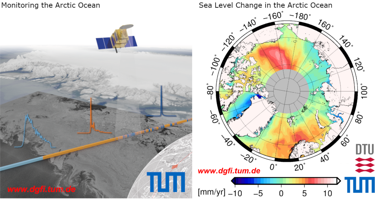
The Arctic Ocean and its polar marginal seas are among the regions of the Earth most affected by climate change. For the most part, they are covered by a dynamically changing sea ice cover, whose extent has a significant impact on the Earth’s climate system. Rising temperatures and increased freshwater input from melting glaciers, in addition to a change in the composition of ocean water, lead to regionally very different changes in sea level and ocean currents in the Arctic Ocean. With the help of remote sensing data from satellite altimetry, these changes have been able to be accurately observed and mapped for around 30 years. In this measurement method, radar or laser pulses are transmitted from satellites, reflected at the Earth’s surface and received again by the satellite. The sea level height is derived from the signal’s travel time. In polar regions, specially developed classification algorithms make it possible to distinguish between reflections from water and ice surfaces. This makes it possible to identify cracks and openings in the ice and to measure the sea surface. Satellite altimetry is a research focus of DGFI-TUM. For the Arctic Ocean, we analyze altimeter data from all available missions over three decades and provide area-wide information on sea level and ocean currents and their temporal changes. The data allow the calculation and investigation of long-term trends and seasonal changes at sub-regional resolution. Our scientific questions relate to the following topics:
Research questions
- How is sea level changing in the polar ocean?
- How do changes in sea level and water composition affect regional and global ocean currents?
- How can ocean tides in the polar ocean be determined more accurately, and how do they change over time?
- How does the sea ice layer change with respect to the number of open water spots, so-called leads?
- How can we further improve the analysis of satellite altimeter data to derive more accurate and long-term stable information about the polar ocean?
Methods
- Processing and scientific analysis of radar and laser altimeter observations (raw data).
- Cross-calibration of all altimeter missions
- Comparisons with in-situ data (tide gauges, surface drifters, ARGO observations, etc.)
- Combination of altimetry with ocean current and tide models
- Operation of the public altimeter database OpenADB (Open Altimeter Database) for altimeter observations and derived scientific data products.
Responsible persons
Deutsches Geodätisches Forschungsinstitut der Technischen Universität München (DGFI-TUM)
- Institute director: Professor Dr.-Ing. habil. Florian Seitz
- Head of Focus Areas Satellite Altimetry: Dr.-Ing. Denise Dettmering
- Satellite Altimetry in polar seas: Dr.-Ing. Felix L. Müller
Projects we participate in
AROCCIE
Arctic Ocean Surface Circulation in a Changing Climate and its Possible Impact on Europe (IGSSE)
ESPOLA
Exploitation of novel SWOT data for polar ocean applications (DFG)
EDAP+
Earthnet Data Assessment Project: Potential of Spire GA GNSS-R data to infer Arctic sea ice freeboard (ESA)