How do melting ice sheets affect sea level rise, and why is it important?
The land ice masses of Antarctica and Greenland hold most of the Earth’s fresh water. The Antarctic Ice Sheet is several thousand meters thick. If it would melt completely as a result of global warming, the global sea level would rise by about 58 meters. A loss of the Greenland Ice Sheet would contribute an additional 7.40 meters.
Many coastal residents are already affected by sea level rise, primarily through increased extreme events such as storm surges. Today, globally, about 40 percent of the population lives near the coast. By 2050, about one billion people will live near the coast, and extreme water levels that historically occurred once in a century, are expected to occur at least once a year in many coastal locations. This has implications for coastal living conditions and for measures to protect people and their livelihoods.
Global sea levels have risen 23 centimeters since the beginning of the 20th century as a result of human-induced climate change. This is due to two processes – the expansion of increasingly warmer ocean waters and the increased melting of ice sheets. Since 2006, the global sea level has risen about two and a half times faster than in the period 1900-1990. This is mainly due to the increased melting of the Greenland and Antarctic Ice Sheets and glaciers. The West Antarctic Ice Sheet has been particularly impacted and has become less stable as a result of the unexpectedly rapid melting. In the coming centuries, increasing warming could reach the tipping point of parts of the Antarctic Ice Sheet – meaning melting would be unstoppable – and sea levels would rise globally by several meters.
Which processes are melting the ice sheets?
Antarctic Ice Sheet:
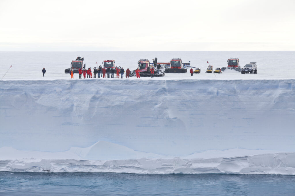
Ice flows due to gravity, much like syrup, but a little slower. An ice sheet is made up of snow that has fallen over a long period of time. Each layer of snow slowly turns to ice because of the weight of the snow that falls on it. Ice streams from Antarctic Ice Sheet flow slowly toward the coast to form ice shelves, the floating extension of the ice sheet on the ocean water (see figure). The grounding line is the point at which the ice sheet is no longer thick enough to rest on solid ground and begins to float. When warm ocean water hits the ice shelves from below, ice is melted there (basal melting). If this basal melting intensifies, ice shelves thin out. An iceberg is formed when part of the ice shelf breaks off, this is called iceberg calving. In extreme cases, ice shelves can become unstable.
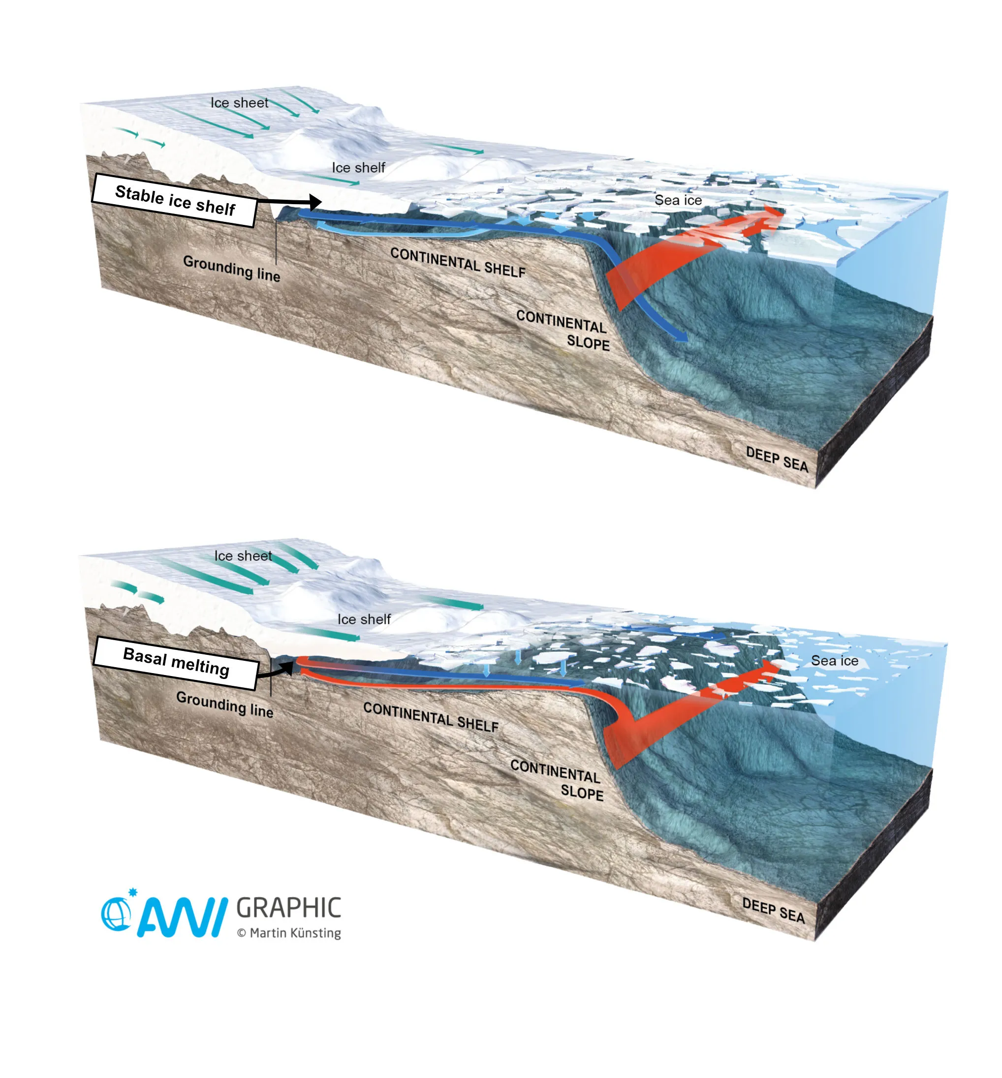
This has happened several times so far on the Antarctic Peninsula. If the ice shelf thickness decreases, then the ice streams accelerate, the mass loss of the ice sheet is increased and the sea level rises faster. The intensity of the ice shelf melting and thus the sea level rise depend on processes that bring warm water masses from the deep ocean over the Antarctic continental slope onto the shelf regions. The warm water then flows beneath the ice shelves, which are several hundred meters thick, and provides the heat for basal melting.
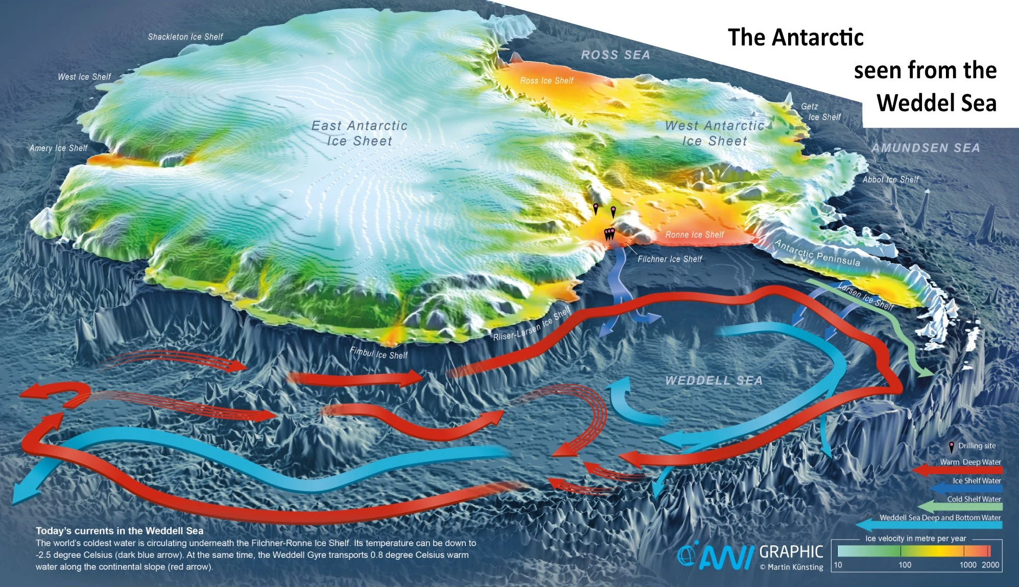
This requires a complex interaction of processes in the ocean, on the continental shelf, and in the atmosphere. On the one hand, winds drive the warm water onto the ice shelves and a retreat of the sea ice favors the basal melting of the ice shelves. On the other hand, winds can also build barriers of salty, cold water on the continental shelves that can displace the warm water. Cold offshore winds can drive sea ice away from the coast, creating ice-free water areas called polynyas. The water in these polynyas is now exposed to a much colder atmosphere, causing it to cool significantly. This results in the formation of new sea ice – which retains very little salt. The water left in the polynyas is very cold, rich in salt, and thus heavy, so it sinks to great depths, driving ocean currents. The influence of warm water under the ice shelf is thus blocked. Under present conditions, this contributes in particular to the stabilization of the Filchner-Ronne Ice Shelf.
Greenland Ice Sheet:
Unlike Antarctica, the Greenland Ice Sheet does not have large-scale ice shelves. However, there are floating glacier tongues in the fjords whose stability is also threatened by basal melting. Today, only three floating glacier tongues exist in northern Greenland. In the south, they have already melted, resulting in the acceleration of glacier flow rates toward the coast. Meanwhile, the north of the Greenland Ice Sheet is also affected by significant mass loss.
The Greenland Ice Sheet is much more sensitive to changes in air temperature than the Antarctic Ice Sheet. The air temperature in Greenland is above freezing in summer, which means that the snow and ice on the surface also melt. The meltwater on the surface of the ice sheet can travel through the ice to the base of the ice sheet, where it can change the flow rate of the ice. When the ice flows faster, more ice flows into the melt zone, contributing to sea level rise.
What is German polar research working on?
According to a special report by the Intergovernmental Panel on Climate Change, the western part of the Antarctic Ice Sheet may have already reached a tipping point, making disintegration irreversible. This would mean that sea levels will rise even faster in the coming centuries than previously assumed. However, these forecasts are subject to a great deal of uncertainty. This is because there are few observations and thus the interactions between the atmosphere, ocean, sea ice, ice sheets, and the solid earth are not yet sufficiently understood. German polar research is working on the following questions:
What are the contributions of melting ice sheets to global and regional sea level rise – today and in the future?
To answer this question, the mechanisms leading to ice loss and sea level rise need to be better understood. Therefore, measurements must be continuously collected to detect changes in the ice masses. This includes, for example, monitoring ice streams, changes in height and mass of the ice sheets and ice shelves, and recording surface and basal melting. Basal melt rates at the ice shelves have only been measured at a few locations. The location of the grounding line (transition from grounded to floating ice) is a key indicator of change.
Also important is improved detection of the influence of geothermal heat on melting. This requires studying the nature of the bedrock beneath the ice-covered areas and the seafloor in the fjords. In particular, in West Antarctica, the Earth’s crust is thinner than at the massive continent base of East Antarctica. There, geothermal heat could affect ice flows.
All this information is needed to represent ocean-ice interactions and flow conditions in models and to achieve realistic projections of the future development of the ice sheets and sea level.
How great is the risk that parts of the Antarctic Ice Sheet and the Greenland Ice Sheet will become unstable or experience extreme mass loss? Have such events already occurred in Earth’s history?
To find out whether the ice sheets are partially or completely at a tipping point, studies of geologic warm periods, when temperatures were higher than today, are of considerable importance. These periods range from the Eemian Warm Period (about 125,000 years ago) to the warm periods of the middle Pliocene (about 3-3.5 million years ago) and middle Miocene (about 14-16 million years ago). From these periods, there is evidence suggesting a partial or complete collapse of the ice sheets.
A collapse of the West Antarctic Ice Sheet may have occurred during the Eemian Warm Period when polar surface temperatures were about two to three degrees Celsius higher than today. This warm period is thus comparable to the temperatures that could be a reality in 2100. Sea levels would rise by three to five meters during this period.
To improve the insights, sediment and ice cores from key regions need to be studied. Furthermore, modeling based on observational data is also needed. The evolution of ice sheets in other warm periods can then be used to identify the critical temperature limits at which ice masses are irreversibly lost.
How does the melting of the Greenland Ice Sheet affect ocean currents and thus regional sea level changes?
Melting of the Greenland Ice Sheet is delivering more freshwater to the northern North Atlantic. If this freshwater is transported to key regions of the climate-relevant Atlantic Ocean circulation diluting the salinity of the water there, then the circulation could further slow down.
The Atlantic current system is driven by differences in salinity and temperature making the surface water in key regions heavier than the underlying water and sinking as a deep current. The warming of surface water due to global warming and the influx of meltwater from the Greenland Ice Sheet weaken the formation of deep water in the Atlantic.
The Atlantic circulation influences, amongst other things, the mild climate in western and northern Europe and rainfall over Africa and South America. A weakened Atlantic circulation is causing regional sea levels in Europe to rise even more than just from ice sheet melting and warming and expansion of the ocean water alone. To clarify the role that meltwater from Greenland will play in the Atlantic circulation, all relevant processes must be well represented in climate models. To improve models, the currents and deep water formation at multiple key areas must be observed for a long time.
How can ice sheet interactions with the ocean and atmosphere be better understood, quantified, and modeled to improve sea level rise projections for the next 100 to 300 years?
According to model calculations, ice masses are shrinking in two steps. The first step is ice shelf retreat. If ice shelves in Antarctica are lost, the ice masses of the ice sheet behind them accelerate, ice transport into the ocean increases, and the sea level rises. The same is true for Greenland’s glacier tongues and glacier flow rates toward the coast. Since both ice sheets represent tipping points for sea level rise, realistic projections from climate models are extremely relevant.
To make better predictions of ice sheet melt and sea level rise, the complex interactions between ice sheets, ocean, and atmosphere must be incorporated into climate models. For example, the models must be able to realistically simulate basal melting and surface melting. The formation of meltwater lakes and wet firn snow on the ice surface change the reflectivity of incoming solar radiation, and this must be accounted for in the models. Changing precipitation over the ice masses and the strong warming of air temperatures in the Arctic due to Polar Amplification also have to be considered. Many of these processes are also significant for Arctic glaciers and ice caps outside of Greenland, and these polar ice masses must also be included in the simulations.
To simulate these complex processes, high-resolution process studies must be embedded in next-generation global climate models. However, new challenges do not only exist in modeling, but also in obtaining measurements to create a high-quality database to validate the model results.